Select sheets and configure your printout
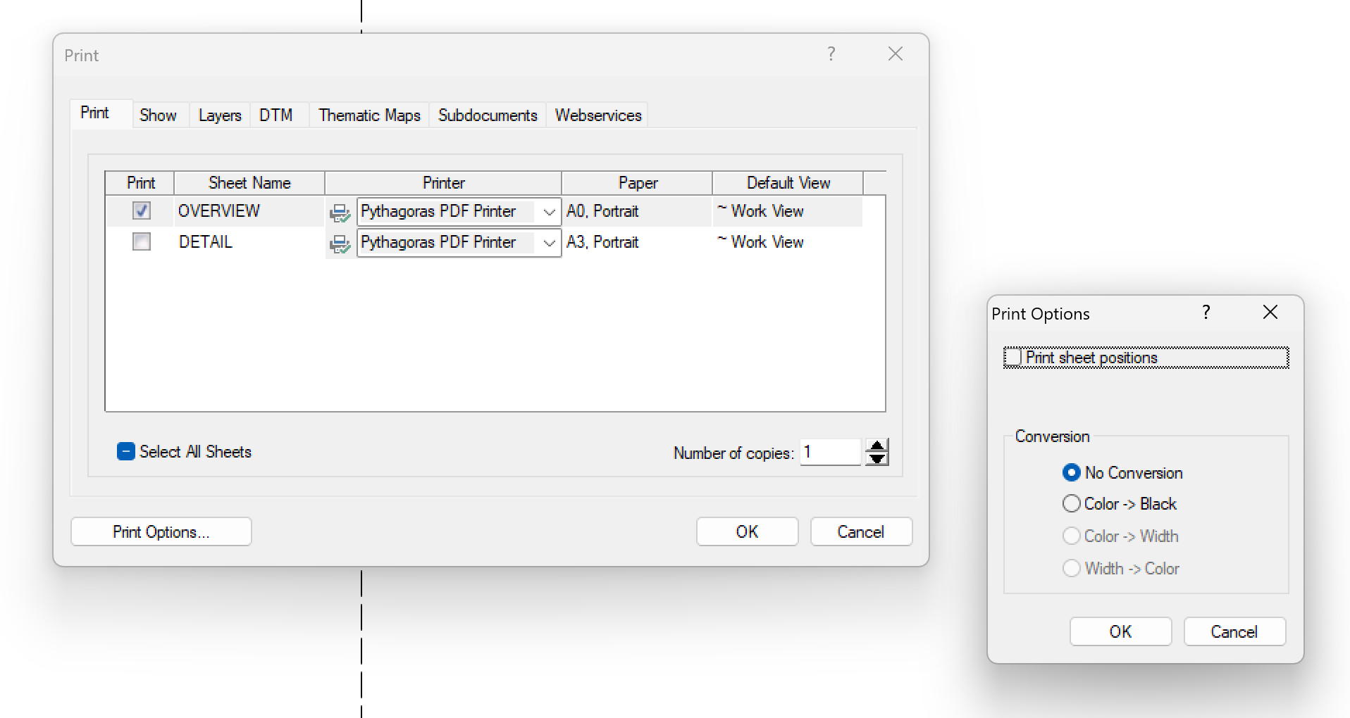
Use File > Print… or Ctrl+P to print one or more sheets. In the Print window, you choose the printer, number of copies, display settings and print options.
Printing
Open File > Print… or press Ctrl+P.
• With a floating sheet, Page Setup becomes active first. Adjust the sheet’s position, scale and rotation if needed, then confirm. The Print window appears.
• With a fixed page setup, the Print window appears immediately.
On the Print tab, select the sheets you want to print. Use Select All Sheets to select them all.
Check the Printer, Paper and Default View for each sheet.
To create a PDF through this window, select a PDF printer in the Printer column.Set the Number of copies.
Adjust the settings on the other tabs or under Print Options… if needed.
Click OK to print.
Want to create a PDF directly? See How to create a PDF in Pythagoras.
Print options
Click Print Options… to convert colors or line widths for the output, or to display sheet positions.
• Display a sheet overview
Enable Print sheet positions to show the sheet outlines on the printout.
The sheet name appears at the bottom-left of each outline. This shows where the different sheets are located within the drawing.
• Conversions
| Option | Result |
|---|---|
| No Conversion | Preserves the configured colors and line widths. |
| Color -> Black | Converts colors to black while preserving line widths. |
| Color -> Width | Converts colors to line widths according to a loaded conversion table. |
| Width -> Color | Converts line widths to colors according to a loaded conversion table. |
The last two options are only available when the corresponding conversion table is loaded.
Want a black-and-white version? Select Color -> Black and click OK. You do not need to change the colors of the drawing objects.
Display settings
The other tabs in the Print window determine which information appears in the printout:
| Tab | What can you configure? |
|---|---|
| Show | Which object information and display elements are included. |
| Layers | Which layers are visible. |
| DTM | How terrain models are displayed. |
| Thematic Maps | Which thematic display is applied. |
| Subdocuments | Which subdocuments are visible. |
| Webservices | Whether webservices are included and at which image resolution. |
Was this article helpful?
That’s Great!
Thank you for your feedback
Sorry! We couldn't be helpful
Thank you for your feedback
Feedback sent
We appreciate your effort and will try to fix the article